AI for Wildfire Safety: How Conformal Risk Control Guarantees Evacuation Security
Explore how Conformal Risk Control (CRC) revolutionizes wildfire evacuation mapping by providing formal safety guarantees, ensuring real-time fire detection and optimizing response.

The Critical Need for Safe Wildfire Evacuation
Wildfires pose an escalating threat globally, making robust evacuation planning more critical than ever. However, current wildfire prediction models, despite their sophistication, harbor a dangerous flaw: they often fail to provide formal guarantees on how much actual fire spread might be missed. In the context of evacuation, a "false negative"—a burning area incorrectly classified as safe—can have catastrophic consequences, directly endangering human lives. Conversely, "false positives"—safe areas mistakenly flagged as dangerous—lead to "shadow evacuations," congesting roads and potentially hindering the escape of those in genuine peril. This delicate balance highlights the inadequacy of traditional accuracy metrics, which can be misleading, especially when fire pixels represent a tiny fraction of the total area.
Traditional models, even those boasting high overall accuracy, can miss a significant portion of actual fire spread due to this extreme class imbalance, where non-fire pixels vastly outnumber fire pixels. For safe evacuation mapping, controlling the pixel-level False Negative Rate (FNR) is paramount. A system that overlooks individual fire pixels cannot establish reliable fire perimeters, regardless of subsequent spatial analysis. This underscores a crucial gap in current wildfire prediction research: despite decades of effort and the emergence of advanced safety tools, the domain where false negatives are most dangerous has lacked formal safety guarantees.
Introducing Conformal Risk Control: Guaranteed Safety for AI Predictions
A groundbreaking approach, Conformal Risk Control (CRC), addresses this critical void by providing formal, distribution-free safety guarantees for AI predictions. Unlike conventional methods that rely on assumptions about data distribution or model calibration, CRC selects a decision threshold from calibration data to ensure that the expected False Negative Rate (E[FNR]) on new, unseen data remains below a specified level (e.g., ≤ 0.05). This guarantee holds true irrespective of the underlying model's quality or how well it's calibrated.
CRC represents a significant leap forward because it offers finite-sample guarantees, meaning these assurances are valid even with a limited amount of data, a common scenario in real-world disaster response. While conformal prediction techniques have gained traction in fields like medical imaging and autonomous driving, their application to geospatial hazard prediction, particularly wildfires, has been largely unexplored. This academic paper, "Conformal Risk Control for Safety-Critical Wildfire Evacuation Mapping: A Comparative Study of Tabular, Spatial, and Graph-Based Models," marks the first known application of CRC to wildfire spread prediction (Source: arxiv.org/abs/2603.22331). It directly tackles the asymmetric cost structure inherent in wildfire scenarios, where missed fires endanger lives and overly broad evacuation zones create operational inefficiencies.
The Flaw in Traditional Wildfire Prediction: A Striking Revelation
The study uncovers a stark and concerning failure in standard wildfire prediction methods. Researchers evaluated three distinct model architectures—ranging in complexity from simple to advanced—against the Next Day Wildfire Spread (NDWS) dataset. These included:
- Tabular Model (LightGBM): A baseline that treats each pixel independently, without considering its neighbors.
- Spatial Model (Tiny U-Net): A convolutional neural network designed to capture local spatial relationships, much like how human vision processes images.
- Graph-Based Model (Hybrid ResGNN-UNet): An advanced model that combines convolutional encoding with graph attention layers to model complex fire propagation patterns across connected pixels.
Despite achieving respectable AUROC scores (a common measure of classification performance), the models, when using standard probability thresholds, demonstrated a severe inability to capture true fire spread. For instance, LightGBM, at its optimal threshold, missed a staggering 92.8% of fires, the U-Net missed 61.0%, and even the more complex ResGNN-UNet missed 28.5%. This means that evacuation planners relying on these traditional outputs would have left a vast majority of fire-affected areas unaddressed, putting lives at extreme risk. This highlights that even models with high reported accuracy can be critically unsafe in scenarios with extreme class imbalance.
Comparing AI Architectures: Efficiency vs. Safety
The research clearly delineates the roles of model architecture and CRC: model architecture determines evacuation efficiency, while CRC guarantees safety. When CRC was applied, all three models achieved consistently high fire coverage (≥94%), effectively eliminating the dangerous failure of missed fires. However, the efficiency—defined by the size of the flagged evacuation zone—varied significantly based on the model's underlying architecture.
Spatial models, like the Tiny U-Net, proved to be significantly more efficient. With CRC applied, both spatial models achieved approximately 95% fire coverage while flagging only about 15% of the total map pixels as potentially affected. This makes them 4.2 times more efficient than the tabular LightGBM model, which, despite achieving the same safety guarantee with CRC, flagged 62.6% of pixels. Interestingly, the additional complexity of the graph-based Hybrid ResGNN-UNet over the simpler U-Net did not yield any meaningful efficiency gains for this particular task. This finding strongly suggests that for wildfire prediction, a strong spatial inductive bias within the model is crucial for effective and efficient evacuation planning, providing targeted safety zones without unnecessarily disrupting large populations. For enterprises requiring robust and efficient spatial analysis, solutions like ARSA AI Video Analytics can be deployed for real-time monitoring.
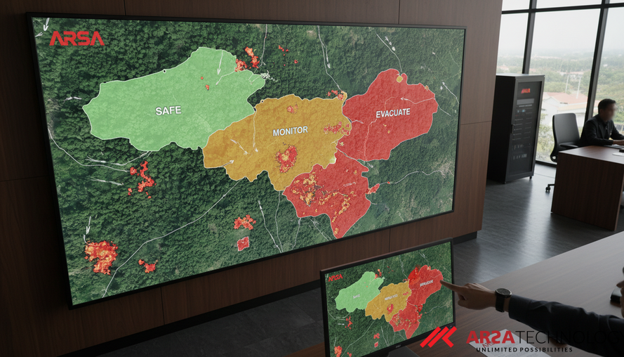
Operationalizing Safety: The Three-Way CRC Framework
To further enhance operational utility, the study proposes a "shift-aware three-way CRC framework." This innovative framework categorizes areas into three zones: SAFE, MONITOR, and EVACUATE. This provides emergency responders and planners with a nuanced understanding of risk, allowing for more strategic and dynamic decision-making during a wildfire event.
- EVACUATE zones: Areas with a high likelihood of fire, where immediate evacuation is necessary.
- MONITOR zones: Areas with moderate risk, requiring close observation and potentially pre-emptive measures.
- SAFE zones: Areas where the risk of fire spread is minimal, allowing for safe passage or refuge.
This tiered approach enables better resource allocation and minimizes the disruptive impact of overly broad, blanket evacuations. The research also sheds light on a fundamental limitation of prevalence-weighted bounds when confronted with extreme class imbalance (e.g., only ~5% fire prevalence). This nuance is vital for practitioners, as it highlights the need for careful consideration when implementing safety guarantees in highly imbalanced datasets. ARSA Technology, with expertise in custom AI solutions, can help organizations design and deploy such sophisticated systems tailored to their specific operational needs, drawing on its team experienced since 2018. Our AI Box Series can serve as turnkey edge systems for rapid on-site deployment in critical environments.
ARSA's Role in Enhancing Public Safety and Operational Resilience
The findings from this pivotal research underscore the profound importance of integrating formal safety guarantees like Conformal Risk Control into AI systems, especially in high-stakes environments such as wildfire management. At ARSA Technology, we are committed to building production-ready AI and IoT solutions that deliver measurable impact and enhance public safety. Our expertise in AI video analytics, edge AI systems, and custom AI development directly aligns with the advancements discussed in this study.
By leveraging advanced computer vision and predictive analytics, ARSA can provide robust platforms capable of integrating safety-critical frameworks like CRC. Imagine a scenario where ARSA’s AI Video Analytics software, running on-premise or on edge devices, processes real-time CCTV or drone footage, then applies CRC to generate highly reliable evacuation maps. This could mean:
- Reduced false negatives: Ensuring that actual fire fronts are detected with guaranteed reliability, preventing missed evacuation warnings.
- Optimized resource allocation: Precisely delineating SAFE, MONITOR, and EVACUATE zones to guide emergency services and avoid unnecessary civilian displacement.
- Enhanced operational efficiency: Providing actionable insights to fire departments and emergency planners, allowing for faster, more effective responses.
Conclusion: A New Era for Safety-Critical AI
The application of Conformal Risk Control to wildfire evacuation mapping represents a critical paradigm shift for safety-critical AI. It moves beyond empirical accuracy to deliver formal, verifiable guarantees on system behavior, directly impacting human safety and operational efficiency. This research emphasizes that while robust AI architectures are essential for efficient predictions, it is CRC that ensures those predictions are dependably safe. For industries facing similar high-stakes challenges, integrating such advanced risk control mechanisms is not just an option but a necessity.
To explore how ARSA Technology can help your organization implement cutting-edge AI and IoT solutions with built-in safety guarantees, we invite you to contact ARSA for a free consultation.